Lava Flows of Time: Isochronic Maps & Mountains

Francis Galton's Isochronic Passage Chart of 1881, one of the first of such maps, indicates the time necessary to travel from London to anywhere else in the world.

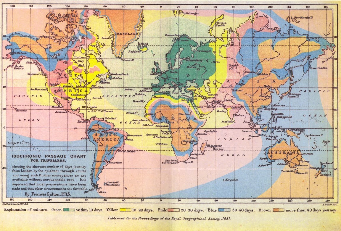
Francis Galton’s Isochronic Passage Chart of 1881, one of the first isochronic maps, indicates the time necessary to travel from London to anywhere else in the world.

Watch enough Star Trek and you will soon overload on the notion of a space-time continuum. Without revisiting Stephen Hawking, let’s agree that there is an intuitive link between these two experiences (space and time) but that we typically conceptualize and visualize each one distinct from the other. In the world of representation there are a number of examples where this rift has been stitched back together. Cartographies of Time by David Rosenberg and Anthony Grafton presents a study of the methods of representing time as they change throughout history, and if we want to understand the experience of space (or data) through map-based representation, there are a number of cartographic techniques that have been developed over the years (Edward Tufte”s books are always a good place to hunt for innovative maps and graphs). But one simple technique that nicely melds space and time is the isochronic map.

1932_Isochronic_map_NYC_rail_Radical_Craft_blog

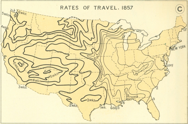
Isochronic map created in the 1930’s showing rail travel times from NYC to other parts of the US, [Image Credit: the 1932 Atlas of the Historical Geography of the US, via Michael Graham Richard]

Isochronic maps are often used by transit planners to quickly spatialize the time it takes to walk, bus, or train from one point to another by establishing boundaries representing uniform travel times. You may have seen these types of maps in projects by Oskar Karlin or the web app Mapnificent. The animation of this kind of data offers even more powerful techniques of visualization:

TIMEMAPS from graphsic on Vimeo.

While these maps are often used to assist commuters in making more informed transit decisions, there is another powerful feature of isochronic maps; historical comparison. Radical Craft’s Isochronic Mountains are intentional misreadings of isochronic lines as topographic lines, materializing the time spent in commute into a mountain of waiting. When placed side by side with the isochronic mountains of other cities, or other moments in time, we can gauge how well any city’s transit infrastructure stacks up. As we compare one urban area to another, the higher the mountain, the more deficient the transit infrastructure: large sprawling cities with transit that has kept pace with development would create plateaus instead of mountains.  São Paulo’s weak transit coupled with is mega-sprawl produces an extreme example:

Sao Paulo Transit Time Comparison_Radical Craft blog

O Morro da Esperança Paulista by Radical Craft. This comparative graph depicts the increase in travel times to and from São Paulo’s city center over the last 75 years. The erosion of public infrastructure becomes evident, due in part to the expansion of the city, but also to the dismantling of the extensive street car (bonde) lines which still existed in 1939.

This new mountain (with the z-axis as time), creates a dynamic topography of the trajectories of travel. Rivers, railways, bridges, and other geographic features, both man-made and natural, impact the accessibility of the various neighborhoods of the city, all registering as geological features – cliff faces and fissures – that channel the lava flows of time. Valleys and the surrounding flatlands represent areas underserved by transit (how many of the region’s favela’s would be condemned to the shadow of access represented by these valleys?).

Radical Craft's Isochronic Mountain of São Paulo's transit in 1939. As the tram lines ply their way into the suburbs, they extend the topography of access emanating from he city center. A chasm appears where access is blocked - here heavy rail lines are crossed only intermittently be bridges which create cascading mounds of connectivity.

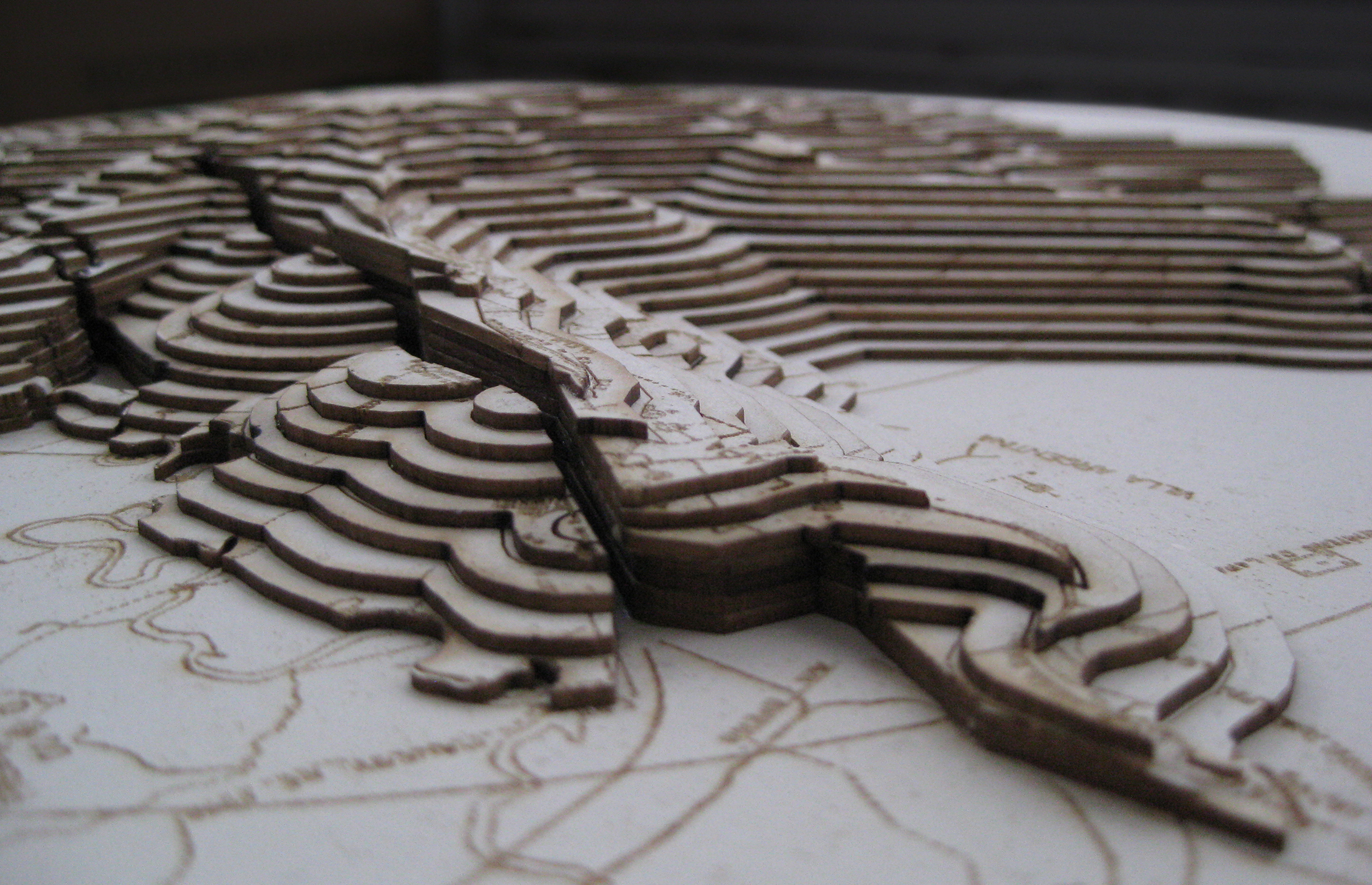
Radical Craft’s Isochronic Mountain of São Paulo’s transit in 1939. As the historic tram lines ply their way into the suburbs, they extend the topography of access emanating from he city center. A chasm appears where access is blocked – here heavy rail lines are crossed only intermittently by bridges which create cascading mounds of connectivity on the other side of the tracks.

While the beautiful precision of the 1833 map below implies an interest in helping urbanized areas avoid being buried by future lava flows, the man-made isochronic mountains of today’s cities offer the possibility of reshaping the terrain of access to the city.

John Richardson Auldjo’s 1833 etching “Map of Vesuvius: showing the direction of the streams of lava in the eruptions from 1631 AD to 1831 AD.” More info at UMD’s Romantic Circles.

John Richardson Auldjo’s 1833 etching “Map of Vesuvius: showing the direction of the streams of lava in the eruptions from 1631 AD to 1831 AD.” More info at UMD’s Romantic Circles.


Shared Waters at the Chicago Architecture Foundation

shared_waters_cover_CAF

After a great turnout and discussion at Part 1: Trickle Up,  Joshua will moderate Part 2: Shared Waters: Chicago, Gary, Milwaukee,­ and St. Louis with Iker Gil. This is the second installment in the After the City, the City discussion series focused on water issues and organized by the Chicago Expander program at Archeworks and Joshua Stein, in collaboration with Skidmore, Owings & Merrill LLP and the Chicago Architecture Foundation.

Tuesday, February 18, 2014 6:00pm, Chicago Architecture Foundation

Panelists: Debra Shore, Commissioner, Metropolitan Water Reclamation District of Chicago; Dean Amhaus, President and CEO, Milwaukee Water Council; Derek Hoeferlin, R.A., Assistant Professor of Architecture, Washington University, St. Louis; Daniel F. Vicari, P.E., BCEE, Executive Director, Gary Sanitary District | Gary Stormwater Management District.

While “Chicagoland” is intended to encompass the larger metropolitan area “anchored” by Chicago, water issues increasingly complexify this centralized diagram. Increasingly, challenges and innovations are tackled in parallel across various nodes in a network. As water connects Chicago to increasingly larger systems, it also connects the city to a network of other cities grappling with similar issues. Experts from Chicago, Gary, Milwaukee, and St. Louis will discuss issues that affect these metropolises through shared waters.

More info at: After the City, the Cityand Chicago Expander at Archeworks.


Mounding Part II: Trash Urbanism (or Top of the Bottom)

Map of Cahokia mound complex from National Geographic.

Map of Cahokia mound complex from National Geographic.

Cahokia Mound settlement sits 9 miles to the northeast of St. Louis, MO (6 miles to the northeast of East St. Louis, IL). While the area was settled in the 7th century CE, mound construction started about 200 years later.  This complex of 120 mounds (now 80) sits in the fertile floodplains of the mighty Mississippi in a territory known as the American Bottom. In this context, Cahokia’s largest mound, Monk’s Mound, is surpassed in height and volume only by the Milam Landfill (also known as Mount Trashmore) in East St. Louis. Only sometime in the last 40 years did this trash heap overtake Monk’s Mound. Was there a ribbon cutting ceremony when this 20th century trash-made mound finally overtook the man-made 9th century one? Given the slow demolition of East St. Louis since the 1960s, we might wonder what material percentage of the modern city was sacrificed to achieve the title of tallest mound in the American Bottom. Could Milam Landfill now be christened Top of the Bottom?

Cahokia_2_Radical_Craft_blog

Just as Cahokia was being settled, 300 years or so before Monk’s Mound was built, other mounds such as those at Crystal River, FL were built of oyster shells. These forms seem intentionally built to serve as temple platforms, but perhaps more interesting were those nearby made of waste (middens) which slowly, maybe unwittingly, came to define different zones within the complex:  a prehistoric form of trash urbanism.

Monte Testaccio in Rome at the turn of the century.

Monte Testaccio in Rome at the turn of the century.

Of course the Romans had their own mountain of trash, Monte Testaccio. What started around 50 CE as a storage heap for discarded amphorae used to ship oil across the sea grew into a hulking ceramic mountain. The material properties of this mounded, fired earth would later be rediscovered when wine caves were excavated into the bottom of the hill, tapping its cool constant temperature for distribution to the drinking establishments that would ring its perimeter.

Caught somewhere between archaeology, geology, and scatology, these mounds pose an earthy challenge to how we live with, on, or in, the past.

For more on Monte Testaccio and what it offers for contemporary landfills, see Michael Ezban’s “The Trash Heap of History.” For more on the agency of the past contained in such living heaps see Jennifer Scappettone’s “Garbage Arcadia: Digging for Choruses in Fresh Kills,” in Terrain Vague: Interstices at the Edge of the Pale.

Satisfying a bonus obsession, an exquisite visitor’s center site model of the Cahokia Mounds transforms the amorphous ambiguity of earthen form into crisply rendered bronze geometry:

Site model at the Cahokia Mounds Interpretive Center

Site model at the Cahokia Mounds Interpretive Center


What Goes Around (almost) Comes Around: Imperfect Circles

It serves me right. After warning many a student of the dangers of the circle as a design trope, I realize that the circle has now found its way into several of our recent projects. I still believe my beef with the circle is legit. The circle plays nice with no one, not even its own kin. Fuller’s Dymaxion House refuses to accept additions, twinnings, or groupings without appearing just plain awkward.

But a degenerate circle, this is a thing of beauty–disintegrated, degraded, deformed, opened to the influence of the outside world in one way or another–the idealism of perfect geometry tempered by the specificity of the material world or the necessities of use and inhabitation. And perhaps the simplicity of the circle’s geometry is most appropriate when used to register precisely these forces of the world which refuse to conform to such simplicity or symmetry.

The open circle of the Great Blue Hole, Lighthouse Reef, Belize, an inspiration for Radical Craft's Soms Atoll proposal.

The open circle of the Great Blue Hole, Lighthouse Reef, Belize, an inspiration for Radical Craft’s Soms Atoll proposal.

Water pools complementing the simple geometry of the Tevetron Collider at Fermilab in Batavia, IL.

Water pools complementing the simple geometry of the Tevetron Collider at Fermilab in Batavia, IL.

The radial porosity of the Trajan's Hollow plaster floor cast, a cross-sectional index of the asymmetries of the original Trajan's Column.

The radial porosity of the Trajan’s Hollow plaster floor cast, a cross-sectional index of the asymmetries of the original Trajan’s Column.

Trickle Up panel discussion in Chicago

Trickle_Up_Radical_Craft_Blog

As part of the After the City, the City discussions, Joshua G. Stein will moderate Trickle Up: The Scale of Water in Chicago with Iker Gil. This series focused on water issues is organized by the Chicago Expander program at Archeworks and Joshua Stein, in collaboration with Skidmore, Owings & Merrill LLP and the Chicago Architecture Foundation.

Wednesday, December 18, 2013 6:00pm, Chicago Architecture Foundation

Panelists: Claire Cahan, Studio Gang; Phil Enquist, FAIA, Partner in Charge of Urban Design and Planning, Skidmore,  Owings & Merrill LLP; Martin Felsen, Principal of UrbanLab; Antonio Petrov, Assistant Professor at UTSA’s College of Architecture and Co-Director of the Chicago Expander program at Archeworks; Frances Whitehead, Civic practice artist and Professor at the School of the Art Institute of Chicago.

After the City,  the City: www.afterthecity.org

Chicago Expander at Archeworks: www.archeworks.org/chicagoexpander

Joshua G. Stein talks City Talk

Public Think Tank

Saturday, November 16, 2003

School of the Art Institute of Chicago

Joshua G. Stein will be presenting a short talk on infrastructure’s connection to city identity.  The talk, which is part of  the Exploring Collaborative City Making: Public Space, Local Policy and Social Innovation think tank, produced by the GFRY Studio of the School of the Art Institute Chicago, will look at the discrepancy between the scale of the contemporary city and its transit infrastructure as researched in the másTransit proposal.  Following this interpolation, Think Tank participants will be challenged to extrapolate on the future of Chicago’s identity as expressed through transit infrastructure.   The all-day think tank, which will also feature talks by Iker Gil (Mas Studio), Victor Margolin (University of Chicago), Laura Forlano (Illinois Institute of Technology), Ken Dunn (Resource Center), and Walter D. Street III (Walter Street Architects), is a part of the GFRY Studio’s larger task of actualizing designs and policy for the democratization of Chicago, and cities around the world. GFRY Studio Publicity Think Tank

Mounding: The Drive to Pile

What’s the easiest way to make a mountain out of a mole-hill? Just keep heaping. Probably the easiest way to make “architecture,” mounding dates back millennia. While Laugier’s Primitive Hut assembles elements from the landscape into architecture, the mound operates simultaneously as architecture and landscape. Unlike other protoarchitectural expressions, mounding – the manipulation of the earth – always seems to connect to the hidden. There is always more than meets the eye in the mound. Prehistoric middens often reveal more information about past societies and ecologies than written documentation. Tombs, sarcophagi, secret passageways, treasure, the unknown…

In Close Encounters of the Third Kind, Roy Neary (played by Richard Dreyfuss) becomes obsessed by a particular unknown form (later understood to be Devil’s Tower, Wyoming, the location of alien contact). Although the profile of this form is striking, it is its massive materiality that is the touchstone for Neary’s obsessive behavior. Instead of simply drawing the stark silhouette of the tower, he sculpts its likeness out of the materials of his every day life: first sculpted dollop of shaving cream, then a mashed potato mound at dinner, and finally, in a coup de grâce, a living room effigy of repurposed bricks and uprooted shrubbery from his lawn and, of course, dirt.


Close Encounters of the Third Kind, Neary's living room mound effigy of Devil's Tower.

Close Encounters of the Third Kind, Neary’s living room mound effigy of Devil’s Tower.

Neary’s mounds, and Devil’s Tower itself, seem just a step away from the mound contained inside Hadrian’s Mausoleum in Rome, whose plan reveals an extreme relationship between habitable space and solid rock/rubble (for more on the prominence of poché in Rome, see this article in FLOOR).

Axonometric view of Hadrian's Mausoleum (now Castel Sant Angelo) in Rome demonstrating mounded earth encased by brick.

Axonometric view of Hadrian’s Mausoleum (now Castel Sant Angelo) in Rome demonstrating mounded earth encased by brick.


David Gissen's proposal for the reconstruction of the Mound of Vendôme (2012). Here the mound indexes the destruction of the Column of Vendôme in Paris, itself a reconstruction of Trajan's Column in Rome.

David Gissen’s proposal for the reconstruction of the Mound of Vendôme (2012). Here the mound indexes the destruction of the Column of Vendôme in Paris, itself a reconstruction of Trajan’s Column in Rome.

Many recent Radical Craft projects follow this obsession, in part  in reaction to architecture’s recent indulgence in the lightweight and superficial. Soms Atoll oscillates between assembled architecture and sculpted landform. Trajan’s Hollow examines the poché (both material and programmatic) of monumental mass. Even Inversion Sky attempts to recreate the thickness and mass out of the thin and airy.

Soms Atoll by Radical Craft oscillates between sculpted landform and assembled architecture.

Soms Atoll by Radical Craft oscillates between sculpted landform and assembled architecture.